Local Png People Walking across Rounderbout in BOROKO, with 2 large Metal Art Sculptures of Birds of Paradise mounted in centre, along Hubert Murray Highway, Port Moresby, on 18-06-2011

along Napa-Napa Road outside MOBIL Fuel Depot in IDUBADA area nea Poreporena Villages at GABI end, overlooking Fairfax Harbour to TOUAGUBA Hill in KONEDOBU, Port Moresby, PNG, on 4-07-2010

Aproaching Rounderbout Junction to Baruni Road from along Napa-Napa Road, close to the new Port Moresby Transport Depot, on 2-07-2011, Port Moresby, PNG

Passing by BOMANO Police College area, is also near the PNG Correctional Service Prison, in BOMANA, on 13-06-2011

Small Red Local KOIKO Trade Store along Napa-Napa Road near Fairfax Harbour, on 2-07-2011, Port Moresby, PNG

Looking into 8 Mile housing area, from along Hubert Murray Highway, Port Moresby, PNG, on 5-06-2011

Outside Buildings in grounds of Pacific International Hospital, along Stores Road in 4 MILE, near Boroko, Port Moresby, on 23-10-2011

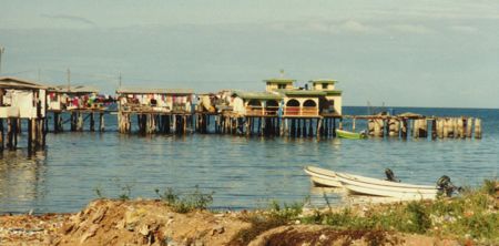
NAPA-NAPA INTER OIL REFINERY area in Port Moresby Fairfax Harbour, with Roku Village in IDLERS Bay across in the CORAL Sea, & Daugo Island above, also known as Fishermans Island, PNG, on 8-05-2012

Village behind Fenceline of Trees along Hubert Murray Highway at 11 Mile area aprox, on 26-10-2011

Government Buildings opposite Murray Barracks across Wards Road near Hubert Murray Highway Rounderbout, on 8-07-2011, Port Moresby, PNG

Looking down and along Scratchley Road in BADILLI area, on 29-10-2011

Primary School and Playing Fields on Corner of Wards Road and side of Poreporena Freeway in HOHOLA area, Port Moresby, PNG, on 30-06-2010

Driving along Champion Parade passing Container Terminal while heading towards Down Town Port Moresby with Paga Hill behind, on 2-07-2011, PNG

ROUNA QUARRIES along Hubert Murray Highway pass 9 Mile area, on 13-06-2011

View looking down Jacksons Airport area towards Bootless Bay, Port Moresby, on 15-10-2011

Turn off Road to DeLaSalle Secondary High School, Near WW11 Bomano Cemetary, PNG, on 10-07-2010

Flowering Bushes in Driveway to House at top of Silkwood Street near corner in HOHOLA area, on 12-11-2011

Local Villages Selling Gravel just outside Rouna Quarries along Roadside at 9 1/2 Mile area, on 26-10-2011

Looking towards HUNAMA Hill on right while passing KOIKO Village area along Napa-Napa Road, on 2-07-2011, Port Moresby, PNG

MAREA HAUS, better known as the PineApple Building, along John Guise Drive in WAIGANI area, [ DISUSED, CONDEMED ], Port Moresby, PNG, Photo by Malum Nalu, on 8-02-2013

ELA Medical Centre and various Shops along Le Hunte Road near Rounderbout at ELA BEACH, on 29-10-2011

Various Business Houses along Cameron Road in GORDONS area, Port Moresby, on 25-10-2011

Roadside view along Hubert Murray Highway out pass 10 Mile area, on 26-10-2011

Very Wet Dirt Road between Village Housing area and ELA RANU Pump Station at BOMANO, on 14-06-2011

Passing Entrance area at Bomana Police College, on 19-10-2011

Looking into local Housing area along Silkwood Street in HOHOLA, on 12-11-2011

View along Taurama Road at Bottom left in East Boroko Area, heading through valley towards Taurama Army Barracks, and BOOTLESS Bay above, With Road to PARI Village on far rightside in Joyce Bay, Port Moresby, PNG, on 10-12-2011

Looking down Hubert Murray Highway to 5 MILE Rounderbout and Boroko Drive, further back is BOROKO area, on 1-07-2011, Port Moresby, PNG

MALALO Estate in 8 MILE area, Port Moresby, PNG, Photo by Malum Nalu, on 6-02-2013

At Jacksons Airport area during Take off, on 10-07-2011

New Housing area near 8 Mile, Port Moresby, PNG, on 8-05-2012

Local Children Walking along OMMO Dirt Street in HORSE CAMP Settlement area, on 22-10-2011

Across Waigani Drive is bemobile Building in GORDONS area, on 21-10-2011

Banana Plants growing along side fence area of Sacred Heart Catholic Primary School along Oak Street in HOHOLA, on 20-10-2011

View along Gavamani Road heading towards SABAMA and Pari Village Road, on 22-10-2011

Small local Stalls on Footpath area along Scratchley Road in SABAMA area, on 29-10-2011

Local PNG Store along Hubert Murray Highway opposite ERIMA J MART Supermarket, called JIMMY Trading Fast Food, Port Moresby, PNG, on 5-06-2011

bottom left, View along Taurama Road in East Boroko area, heading up through Valley to centre right is TAURAMA Army Barracks, with the BOOTLESS INLET above, Port Moresby, PNG, on 10-12-2011

Saint Mary's Medical Centre in BOROKO along Hubert Murray Highway, Port Moresby, PNG

Looking along Ela Beach Road near SDA Church area in Walter Bay, on 29-10-2011

Neem Tree alongside Wards Road in HOHOLA area, on 26-02-2012

At top of 3MILE Hill along Hubert Murray Highway with Korobosea Drive on leftside, and Pruth Street across, on 22-10-2011

INTER OIL Service Fuel Station along Champion Parade, looking from old Port Road in KONEDOBU area, on 22-11-2011

MALAORO SuperMarket area behind local MALAORO Produce and Fish Market along Gavamani Road in KOROBUSEA area, on 20-10-2011

Approaching Hubert Murray Highway from Quarry side Road at 11 Mile area, on 25-10-2011

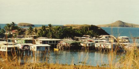
part of KOIKO area along Napa-Napa Road along Fairfax Harbour, on 2-07-2011, Port Moresby, PNG

Catholic Youth inside Covered Sports area along Taurama Road at Don Bosco Technological Institute, in East Boroko, on 12-11-2011

Driving down lower end of Airvos Avenue on TOUAGUBA Hill in NEWTOWN, on 2-07-2011, Port Moresby, PNG
Photos provided by Panoramio. Photos are under the copyright of their owners.